
Most journeys begin by checking a train schedule, ferry departure or flight time. On the world’s tidal islands, travelers check something older: the tide.
Across coastlines from England to South Korea, islands are connected to the mainland by roads, beaches and stone causeways that exist only temporarily. At low tide, people walk, drive, work and explore. Hours later, the same route can be beneath the sea.
These disappearing connections make tidal islands unusual places to visit, but they also reveal something deeper: communities and tourism can build roads and schedules around the coast, but sometimes the ocean still decides when people come and go.
Holy Island: When the Road Home Disappears
About a mile off England’s Northumberland coast lies Holy Island, or Lindisfarne, a tidal island where getting there still depends on the sea. The island is accessible by road at low tide, when a causeway connecting it to the mainland emerges from the water. The modern metalled causeway was completed in 1954, although an older route across the sands existed long before it.
For visitors, reaching Holy Island requires more than following a map. The causeway is cut off twice a day by incoming tides, so drivers, cyclists and pedestrians need to plan their journeys around official safe-crossing times, which change daily. Local guidance also recommends allowing additional time because weather conditions, including strong winds, can affect the crossing.
Once the tide returns, road access is temporarily lost until the sea retreats again. This means sightseeing, arrivals and departures all have to work around the water. For those living and working on Holy Island, that changing connection is simply part of everyday island life.
Here, the tide does more than reshape the coastline. Twice each day, it changes the island’s relationship with the mainland.
Passage du Gois: France’s Disappearing Highway
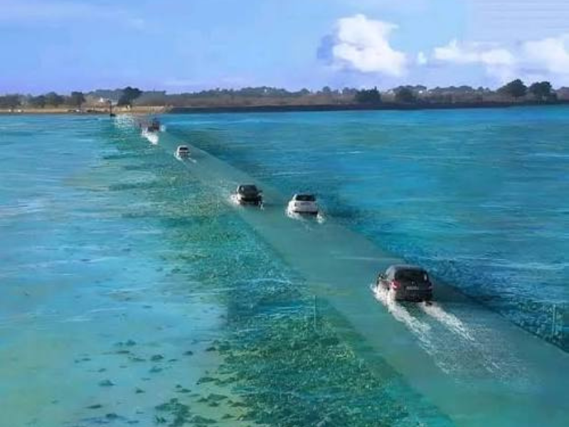
On France’s Atlantic coast, the Passage du Gois connects Noirmoutier Island with the mainland. But calling it a road only tells half the story.
The 4.2-kilometer submersible road is hidden beneath the water for roughly half the time, reappearing as the tide retreats. Travelers therefore need to check tide times before attempting the crossing. Noirmoutier also has a permanent bridge, open around the clock, so while the Gois disappears, the island itself is no longer completely cut off.
Low tide does more than reopen the road. Around the Gois, people head onto the exposed tidal landscape to gather clams, cockles and oysters. Oyster farming has also developed here, with the low tide providing access to oyster beds.
For a few hours, the Gois functions simultaneously as a road, a workplace and a tidal landscape open to exploration. Its changing uses show how coastal infrastructure can remain embedded in natural rhythms rather than separated from them.
St Michael’s Mount: Walk There, Sail Back
At Cornwall’s St Michael’s Mount, the journey itself changes with the sea. At low tide, an ancient cobbled causeway emerges, tracing a route followed by pilgrims, traders, nobles and villagers for hundreds of years. Visitors can walk across to the island during this window, with the causeway generally accessible for around four hours each day, depending on tides and weather. The crossing itself takes roughly 15 minutes.
Timing matters. The cobbled path is uneven, and crossing outside the recommended times can be hazardous. As the tide rises, the sea can return quickly, bringing strong currents and reduced visibility before eventually submerging the causeway altogether.
Then the journey changes.
At high tide, boats take over, carrying visitors across the water while the ancient pathway lies hidden beneath it. The result is an unusual form of tidal mobility: visitors may cross centuries-old cobbles in one direction and return across the same stretch of coast by boat.
Traveling on the Tide’s Terms
What makes these crossings unusual is not simply that they disappear. It is how quickly ordinary travel habits have to adjust around them. A road needs a tide table. A walking route has a closing time set by the sea. A journey that begins on foot may end by boat.
For travelers accustomed to transport operating around human schedules, tidal islands reverse the arrangement. Here, the journey works on the coast’s timetable.
Mont Saint-Michel: Where the Sea Travels 15 Kilometers
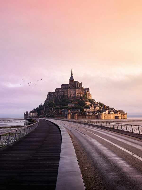
Few tidal landscapes are as dramatic as the bay surrounding France’s Mont Saint-Michel, home to the highest tides in continental Europe.
The difference between low and high tide can reach an extraordinary 15 meters. During the great tides, the sea can withdraw as far as 15 kilometers from the coast before returning remarkably quickly. The strongest tides generally occur 36 to 48 hours after a full or new moon, although weather conditions can influence their timing and height.
The transformation is not constant. During neap tides, the sea does not reach the rocky Mount, but during spring tides it sweeps back across the bay and reaches Mont Saint-Michel roughly four and a half hours after the water begins to rise. This happens approximately once every fortnight, dramatically changing a vast expanse of exposed sand into open water.
Today, visitors depend less on the tides for access than travelers once did. A raised bridge-walkway provides a more reliable connection between Mont Saint-Michel and the mainland, while major engineering works in the bay have helped restore the Mount’s maritime character.
Yet the sea still controls the landscape. Its return can be rapid, and the official tourism authority warns against venturing into the bay alone. The rising water can also produce a tidal bore, a fast-moving wave that travels through parts of the bay and into the Sée, Sélune and Couesnon rivers.
At Mont Saint-Michel, the tide does more than alter access. Across several kilometers of the bay, it repeatedly changes the boundary between land and water.
Jindo: When a Disappearing Road Becomes the Attraction
In South Korea, the relationship between tides and tourism takes another form. At Jindo, falling water reveals a remarkable 2.8-kilometer sea road, around 40 meters wide, between Hoedong-ri and Modo-ri. Although the tides rise and fall twice a day, the route becomes fully exposed for about an hour, creating what has become known as the Jindo Miracle Sea Road.
The phenomenon has grown into an attraction in its own right. Jindo County says around one million Korean and international visitors gather each year to witness the temporary pathway appear from beneath the sea. During the Jindo Miracle Sea Road Festival, visitors can walk across the exposed seabed, while the celebrations showcase some of the county’s distinctive folk traditions, including Ganggangsullae circle dancing, Jindo Ssitgimgut shaman rites, traditional field songs and drum performances.
Its international fame has an interesting history, too. According to Jindo County, the phenomenon gained wider attention after Pierre Landy, then French ambassador to South Korea, visited Jindo in 1975 and wrote about it in a French newspaper. It was likened to a modern-day “Moses’ miracle”, helping transform an unusual tidal event into something known far beyond the Korean coast.
At Jindo, the disappearing road is more than a way across the water. For roughly an hour, the exposed seabed becomes a pathway, gathering place and stage for local culture, turning a tidal event into a form of cultural infrastructure.
Jindo shows what can happen when a temporary tidal route becomes a spectacle that draws enormous crowds. Elsewhere, the same relationship with the sea remains much quieter – determining whether a handful of visitors can reach an archaeological site at all.
Brough of Birsay: Opening Hours Set by the Ocean
Not all tidal islands attract enormous crowds. Off Orkney in Scotland, the Brough of Birsay has perhaps the most unusual opening hours of all: open year-round, but accessible only at low tide.
Visitors reach the island on foot across a tidal causeway, where centuries of history wait on the other side. Archaeological finds including brooches, rings and dress pins suggest Birsay was once an important Pictish power center. Norse settlers arrived around 200 years later, in the ninth century, leaving behind houses, barns and even the remains of what may have been a sauna. A small church and monastery followed in later centuries.
Once across, visitors can explore the remains of the Norse village and St Peter’s Church before walking towards the small lighthouse perched at the island’s crest. The surrounding machair, or coastal grassland, brings another dimension to the landscape, with wildflowers and, in spring, the possibility of spotting puffins nesting along the cliffs above the Atlantic.
But all of this depends on timing the journey correctly. When the tide covers the causeway, ordinary visitor access ends until the sea retreats once more.
No conventional opening hours can override that schedule. At Birsay, the ocean effectively opens and closes the gate.
When the Ocean Writes the Timetable
The fascination of tidal islands lies partly in their impermanence. A road can become seabed. A morning walk can require an afternoon boat. An archaeological attraction can close without locking a gate.
They also reverse the relationship modern travelers usually have with time. Tourism often promises convenience: faster transport, permanent connections, and destinations available whenever we want them.
Tidal islands ask for something different: check the water, know when it will return and arrive when the coast allows it. In places increasingly designed around permanent access and human convenience, these islands preserve a different relationship with movement and time, one in which the natural environment still sets the terms.
Read More On: